
Blaenavon Industrial Landscape
THE area around Blaenavon is evidence of the pre-eminence of south Wales as the world’s major producer of iron and coal in the 19th Century. All the necessary elements can still be seen – coal and ore mines, quarries, a primitive railway system, furnaces, workers’ homes, and the social infrastructure of their community.
Description [from UNESCO] under license CC-BY-SA IGO 3.0
Outstanding Universal Value
The landscape of Blaenavon, at the upper end of the Avon Llwyd valley in south Wales, provides exceptional testimony to the area’s international importance in iron making and coal mining in the late 18th and the early 19th Century. The parallel development of these industries was one of the principal dynamic forces of the Industrial Revolution.
The major preserved sites of Blaenavon Ironworks and Big Pit, together with the outstanding relict landscape of mineral exploitation, manufacturing, transport, and settlement which surrounds them, provide an extraordinarily comprehensive picture of all the crucial elements of the industrialisation process: coal and ore mines, quarries, a primitive railway system and canal, furnaces, workers’ homes, and the social infrastructure of the early industrial community. The area reflects the pre-eminence of south Wales in the production of iron, steel and coal in the 19th Century.
The Blaenavon Ironworks (circa 1789) provided the main impetus for mineral workings and settlement. The remains of the late 18th Century furnaces, together with later 19th Century furnaces, are the best preserved of its period in the United Kingdom. Beside the furnaces, two of the original casting houses can still be seen. Above the furnaces is a range of ruined kilns in which iron ore was calcined or roasted. The remains of the original workers’ housing provided on site can still be seen around the original base of the massive chimney to the blowing engine house, and the cast-iron pillars and brackets which carried blast pipes to the furnaces still survive. The iconic water balance tower of 1839 is an excellent example of lift technology using water to counter-balance loads.
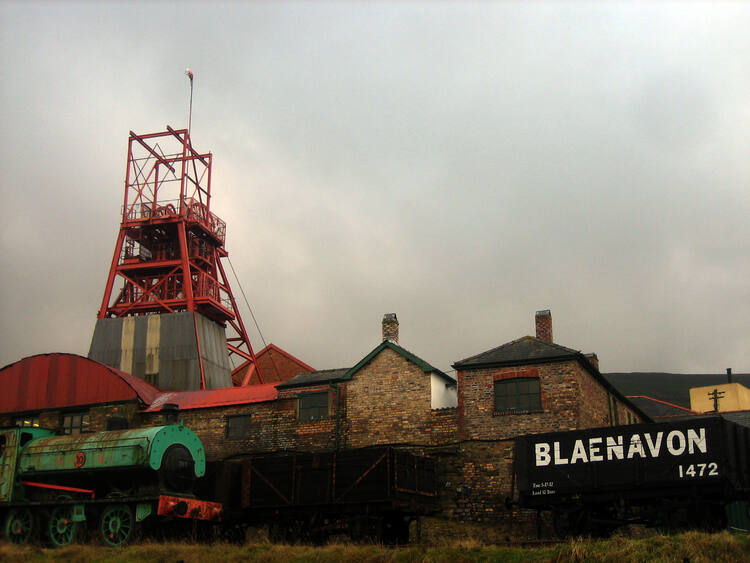
The Big Pit was the last deep coal mine to work in the Blaenavon area, and the surface buildings, including the winding gear, remain almost exactly as they were when coal production ceased in 1980. The underground workings are still in excellent condition and can be seen on guided tours.
The Blaenavon landscape reflects ways in which all the raw materials necessary for making iron were obtained. The landscape includes coal, iron ore, fireclay and limestone workings and transport systems including a primitive iron-railed railway, leading to the canal and later steam railway tracks which were used for the import and export of materials.
The landscape also reflects the development of early industrial society. Close to the Ironworks and Big Pit is the town of Blaenavon, the best preserved iron town of its period in the United Kingdom. Here can be seen the terraced housing of the workers. Overall the town reflects powerfully the distinctive culture that had developed in ironworking and coal-mining areas of the South Wales Valleys and provides a complete picture of patronage and the social structure of the community. Notable buildings include St. Peter’s Church, built by the ironmasters in 1804; the Blaenavon Workmen’s Hall, built by workers’ subscriptions in 1894; and St. Peter’s School, built by the ironmaster’s sister, Sarah Hopkins, in 1816. The school has been restored as the United Kingdom’s first dedicated World Heritage Interpretation Centre.
Taking all these elements together, the property provides one of the prime areas in the world where the full social, economic and technological process of industrialisation through iron and coal production can be studied and understood.
Criterion (iii): The Blaenavon Landscape constitutes an exceptional illustration in material form of the social and economic structure of 19th Century industry.
Criterion (iv): The components of the Blaenavon Industrial Landscape together make up an outstanding and remarkably complete example of a 19th Century industrial landscape.
Integrity
The boundary of the World Heritage property encompasses the major monuments, the mining settlement as well as the surrounding valley landscape with its extensive remains of coal and ore mining, quarrying, primitive iron railways, and canals and thus includes all the key attributes of this early industrial period during the formative years of the Industrial Revolution.
Many of the attributes were vulnerable as a result due to the lack of conservation at the time of inscription. Extensive conservation work has since been undertaken at the Ironworks, Big Pit, the settlement of Blaenavon and in the landscape. All work has been undertaken with the benefit of research and in the context of conservation plans. A programme of continuing conservation of the wider landscape is now being undertaken.
The landscape includes new settlements surrounding the mining town and this is highly visible from higher ground surrounding the town. Therefore any further new development needs to be controlled so as to ensure that the essential values and the important views of the property are not diminished. There is no buffer zone and the setting could be vulnerable to the re-use of spoil heaps, open-cast mining proposals, wind farms and other interventions. However, to date, such proposals have been successfully resisted in accordance with agreed planning policy.
Authenticity
The key attributes are clearly visible. The relationship between the main monuments (the Blaenavon Ironworks and Big Pit), the historic transportation infrastructure, the settlement pattern and the extensive derelict mineral workings can be appreciated, studied and understood. The main heritage features remain in a remarkably complete condition. These substantial and interrelated remains provide opportunities to comprehend the complex process of industrialisation through iron and coal production and the development of industrial society during the early formative years of the Industrial Revolution. Nevertheless the overall ensemble is vulnerable to development that might intrude upon its readability.
To ensure the effective after use and sustainable future for monuments and buildings and to make the presentation and interpretation of the property effective it has been necessary in some situations to provide additional structures or to make minor adaptation to the historic fabric. In such cases the work has been carried out in accordance with agreed conservation plans and the changes and additions can be clearly identified.
Protection and management requirements
A comprehensive system of statutory control operates under the provisions of the Town and Country Planning Act (1980) and the Planning (Listed Buildings and Conservation Areas Act,1990). A network of strategic policies is also in place to protect the property in the Local Development Plans of the Torfaen County Borough Council, the Brecon Beacons National Park Authority and the Monmouthshire County Council. These are the local authorities with statutory planning responsibility for their respective areas within the property.
There are 24 Scheduled Ancient Monuments (SAM) and 82 buildings or structures on the national List of Buildings of Special Architectural or Historic Interest (Listed Buildings). There are two conservation areas within the property, the Blaenavon Town Centre and Cwmavon, and a further conservation area is currently proposed for Forgeside and Glantorfaen. These provide local protection. The main monuments and buildings in the site are within public ownership.
Property management is guided by a Management Plan. The original Plan has been completed (in terms of projects) and has been superseded by a periodically revised Plan. This plan contains the programme of continuing conservation and protection, including a proposed buffer zone which is expected to be considered within the plan period.
There is a need to promote the wider understanding of the scope and extent of the property, and its inter-related attributes. A World Heritage Centre was opened in 2008 which enables visitors to access and understand the World Heritage property both intellectually and physically.
Tourism and visitor management is directed by the Management Plan. This plan contains key management objectives for the promotion, appropriate access and visitor management.
Overall management responsibility for the Property and for delivering the Plan is through the Blaenavon Partnership which brings together a number of local authorities, Welsh Assembly Government Agencies and other bodies under the leadership of Torfaen County Borough Council.
The partnership engages with the wider community, maintaining regular contact with Blaenavon Town Council, voluntary groups, business leaders, residents and the local tourist association. To ensure effective stakeholder participation within the open landscape, a Commons Forum has been established.
There is a need to ensure continuing effective development control within the property and its setting in order that any development does not impact adversely on the relationship between attributes and the surrounding landscape in terms of the integrity of the property and its ability, as a cultural landscape, to convey its Outstanding Universal Value.
Reproduced with thanks to United Nations Educational, Scientific and Cultural Organisation (UNESCO)
BACK TO HOME PAGE