
Pembrokeshire Coast National Park
Pembrokeshire Coast National Park runs along the Pembrokeshire coast in west Wales and was established as a National Park in 1952. It is one of three national parks in Wales, the others being the Brecon Beacons and Snowdonia. It is the only national park in the United Kingdom to consist entirely of wild and maritime landscape.
The National Park has a varied landscape of rugged cliffs, sandy beaches, wooded estuaries, wild inland hills, the moorland of the Preseli Hills and the wooded Gwaun valley. The total area is 629km2 (243sq miles). There are four distinct sections; clockwise, these are: the south Pembrokeshire coast, including Caldey Island; the Daugleddau estuary; the St Bride’s Bay coast, including the coastal islands; and the Preseli Hills.
The geology of the area is of particular interest with many good exposures both inland and along the coast, exhibiting a variety of rock types and structural features such as natural arches, stacks, rock folding and sea caves. A stack of note is Stack Rocks (Creigiau Elegug), two large detached pillars of limestone which in the spring provide valued nesting sites for razorbills and guillemots.
In the north, the rocks of Carn Llidi, Pen Beri and Garn Fawr, together with the extensive moorland on Mynydd Carningli and Mynydd Preseli, give an exposed and mountainous feel to the landscape, cut through by the wooded valleys of the Gwaun and Nevern. In the west, the National Park is dominated by the broad sweep of St Bride’s Bay, bounded at its northern end by Ramsey Island, near St David’s peninsula, and at its southern end by Skomer.
The southern coast is another contrast, with the limestone plateau and cliffs of the Castlemartin peninsula, the steep-sided wooded valleys inland from Amroth; the Bosherston lakes — now, like much of the coastal strip, in the care of the National Trust — and the tourist resorts of Tenby and Saundersfoot. Between the western and southern areas of the National Park lies the Milford Haven waterway, where the tranquil Daugleddau estuary feeds into one of the finest natural deep water harbours in the world.
The National Park includes many sites (such as Pentre Ifan) of historic and archaeological importance and areas which are of national or international nature conservation significance in their own right, including seven Special Areas of Conservation, a Marine Nature Reserve, six national nature reserves and 75 Sites of Special Scientific Interest.
In 2011, National Geographic Traveler magazine voted Pembrokeshire the second best coastal destination in the world for sustainable tourism.
The Pembrokeshire Coast Path is a designated National Trail. It was established in 1970, and is 186 miles (299km) long, much of it at cliff-top level, with a total of 35,000 feet of ascent and descent.
The southern end of the path is at Amroth. The northern end was regarded as being at Poppit Sands, near St Dogmaels, where the official plaque was sited; however, the path now continues to St Dogmaels, where a new marker was unveiled in July 2009, and links with the Ceredigion Coast Path to continue northwards as part of the Wales Coast Path, the 870-mile (1,400km) long-distance walking route around the whole coast of Wales from Chepstow to Queensferry, which was officially opened in 2012.
The Park is managed by Pembrokeshire Coast National Park Authority, which also has responsibility for the entire length of the Pembrokeshire Coast Path.
Over the years Pembrokeshire’s beaches, all of which lie in the National Park, have been awarded many International Blue Flag Awards (10 in 2014), 47 Green Coast Awards (15 in 2011) and 106 Seaside Awards (31 in 2011). In 2011, it also had 39 beaches recommended by the Marine Conservation Society.
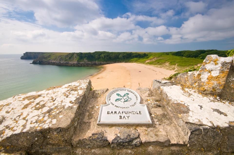
Beaches in the park include: Abereiddy, Amroth, Barafundle Bay, Broad Haven, Broad Haven South, Freshwater East, Freshwater West, Manorbier, Marloes, Newgale, Newport, Poppit Sands, Sandy Haven, Saundersfoot, Tenby, Whitesands Bay.
BACK TO HOME PAGE