
Pontcysyllte Aqueduct and Canal
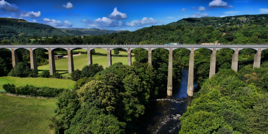
WITHOUT doubt one of the most majestic sights in north east Wales, the Pontcysyllte Aqueduct is a navigable aqueduct that carries the Llangollen Canal across the River Dee in the Vale of Llangollen.
The 18-arched stone and cast iron structure is for use by narrowboats and was completed in 1805 having taken 10 years to design and build. It is the longest aqueduct in Great Britain and the highest canal aqueduct in the world.
The structure is a Grade I listed building and a UNESCO World Heritage Site, one of only three in Wales.
The aqueduct was to have been a key part of the central section of the proposed Ellesmere Canal, an industrial waterway that would have created a commercial link between the River Severn at Shrewsbury and the Port of Liverpool on the River Mersey.
Although a less expensive construction course was surveyed further to the east, the westerly high-ground route across the Vale of Llangollen was preferred because it would have taken the canal through the mineral-rich coalfields of north east Wales.
However, only parts of the canal route were completed because the expected revenues required to complete the entire project were never generated. Most major work ceased after the completion of the Pontcysyllte Aqueduct in 1805.
The aqueduct was designed by civil engineers Thomas Telford and William Jessop for a location near an 18th-Century road crossing, Pont Cysyllte. After the westerly high-ground route was approved, the original plan was to create a series of locks down both sides of the valley to an embankment that would carry the Ellesmere Canal over the River Dee.
After Telford was hired the plan was changed to an aqueduct that would create an uninterrupted waterway straight across the valley.
The work took around 10 years from design to construction, at a cost of around £47,000. Ironwork was supplied by William Hazledine from his foundries at Shrewsbury and nearby Cefn Mawr.
The Pontcysyllte aqueduct officially opened to traffic on November 26, 1805. A plaque commemorating its inauguration reads:
The nobility and gentry, the adjacent Counties having united their efforts with the great commercial interests of this country. In creating an intercourse and union between England and North Wales by a navigable communication of the three Rivers, Severne [sic] Dee and Mersey for the mutual benefit of agriculture and trades, caused the first stone of this aqueduct of Pontcysyllty [sic], to be laid on the 25th day of July MDCCXCV [1795].
The bridge is 336yd (307m) long, 12ft (3.7m) wide and 5ft 3in (1.60m) deep. It consists of a cast iron trough supported 126ft (38m) above the river on iron arched ribs carried on 18 hollow masonry piers (pillars). Each of the 18 spans is 53ft (16m) wide.
(Picture credit: wrexham-history.com)
With the completion of the aqueduct, the next phase of the canal should have been the continuation of the line to Moss Valley, Wrexham, where Telford had constructed a feeder reservoir lake in 1796. This would provide the water for the length of canal between Trevor Basin and Chester. The plan to build this section was cancelled in 1798, and the isolated feeder and a stretch of navigation between Ffrwd and a basin in Summerhill was abandoned. Remnants of the feeder channel are visible in Gwersyllt. A street in the village is still named Heol Camlas (Canal Way).
With the project incomplete, Trevor Basin just over the Pontcysyllte aqueduct would become the canal’s northern terminus. In 1808 a feeder channel to bring water from the River Dee near Llangollen was completed. In order to maintain a continual supply, Telford built an artificial weir known as the Horseshoe Falls near Llantysilio to maintain water height.
Subsequently, the Plas Kynaston Canal was built to serve industry in the Cefn Mawr and Rhosymedre areas in the 1820s. Goods traffic was brought down to the canal by the Ruabon Brook Tramway which climbed towards Acrefair and Plas Bennion. This railway was eventually upgraded to steam operation and extended towards Rhosllannerchrugog and Wrexham.
Commercial traffic on the canal greatly declined after a waterway breach near Newtown, Powys (now part of the Montgomery Canal) in 1936. By 1939 boat movements across the aqueduct to Llangollen had ceased. The canal was formally closed to navigation and, on September 6, 1945, due to inadequate maintenance, the canal breached its banks east of Llangollen near Sun Bank Halt. The flow of hundreds of tons of water washed away the embankment of the railway further down the hill. This caused a mail and goods train composed of 16 carriages and two vans, to crash into the breach, killing one and injuring two engine crew.
The aqueduct was saved (despite its official closure to waterway traffic) because it was still required as a water feeder for the remainder of the Shropshire Union Canal. The aqueduct also supplied drinking water to a reservoir at Hurleston. In 1955 the Mid & South East Cheshire Water Board agreed to maintain the canal, securing its future.
In the latter half of the 20th Century, leisure boating traffic began to rise. In a rebranding exercise by British Waterways in the 1980s, the former industrial waterway was renamed the Llangollen Canal. It has since become one of the most popular canals for holidaymakers in Britain because of its aqueducts and scenery. The Pontcysyllte Aqueduct is now maintained and managed by the Canal & River Trust.
In nearby Cefn Mawr a high quartz content sandstone was discovered at the location where the New Cefn Druids football stadium has since been built. Known locally as ‘The Rock’, the sandstone was extracted and worked here into the many numerous shapes as required by the architects. Many remnants of the workings are still visible alongside Rock Road which links Rhosymedre to Plas Madoc.
The towpath is mounted above the water, with the inner edge carried on cast-iron pillars in the trough. This arrangement allows the water displaced by the passage of a narrow boat to flow easily under the towpath and around the boat, enabling relatively free passage. Pedestrians, and the horses once used for towing, are protected from falling from the aqueduct by railings on the outside edge of the towpath. The trough sides rise only about six inches (15cm) above the water level, less than the depth of freeboard of an empty narrow boat, so the helmsman of the boat has no visual protection from the impression of being at the edge of an abyss.
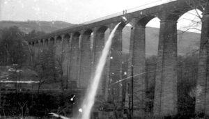
Every five years the ends of the aqueduct are closed and a plug in one of the highest spans is opened to drain the canal water into the River Dee below, to allow inspection and maintenance of the trough.
The aqueduct and surrounding lands were submitted to the ‘tentative list’ of properties being considered for UNESCO World Heritage Site status in 1999. The aqueduct was suggested as a contender in 2005 — its 200th anniversary year — and it was formally announced in 2006 that a larger proposal, covering a section of the canal from the aqueduct to Horseshoe Falls would be the United Kingdom’s 2008 nomination.
The length of canal from Rhoswiel, Shropshire, to the Horseshoe Falls, including the main Pontcysyllte Aqueduct structure as well as the older Chirk Aqueduct, were visited by assessors from UNESCO during October 2008, to analyse and confirm the site management and authenticity. The aqueduct was inscribed by UNESCO on the World Heritage List on June 27, 2009.
More: On top of the world at Pontcysyllte Aqueduct (Visit Wales)